San Diego MTS adopts LiDAR technology to enhance track assessment
It’s similar to Google’s Street View system, which offers users panoramic views from on-the-ground positions along many streets and neighborhoods in the world.
by METRO Staff
June 12, 2017
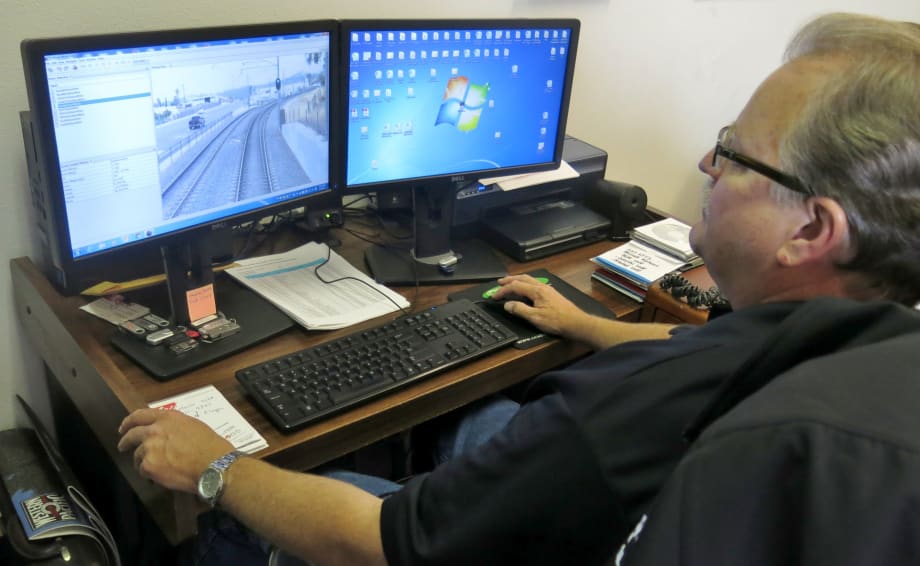
“It really comes in handy to pin down locations using GPS coordinates with contract work,” said Fred Byle, MTS superintendent, wayside maintenance (pictured using the system).
4 min to read
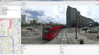
The Roadview Workstation is similar to Google’s Street View system, which offers users panoramic views from on-the-ground positions.
A new image-enhancing technology has been adopted by the San Diego Metropolitan Transit System’s (MTS) rail division that provides pinpoint accuracy of the agency’s 106 miles of track and more clarity about the work ahead even before employees step foot on the right-of-way. The word is now spreading to other departments that are finding it useful as well.
It’s called Roadview Workstation — a technology-driven software solution developed through a laser-guided mapping and detection technology called LiDAR.
Ad Loading...
“Roadview allows MTS to find, map, and categorize everything along the right-of-way. It’s helped our track team analyze work that needs to be done faster and more efficiently,” said Paul Jablonski, MTS CEO.
It’s similar to Google’s Street View system, which offers users panoramic views from on-the-ground positions along many streets and neighborhoods in the world.
MTS hired Mandli Communications to take the Google Street View idea from the streets to the rails. Using a front-mounted camera on a light rail vehicle that traveled on all three lines, a panorama of stitched images consisting of the entire MTS right-of-way was created.
“MTS needed to create an accurate GIS inventory of all of our trackside assets,” said MTS Enterprise Business Solutions Manager Robert Borowski. “Our right-of-way covers approximately 54 linear miles.”
This was needed for the implementation of the agency’s Enterprise Asset Management system, which in turn was developed to meet the needs for state of good repair in accordance with MAP-21, he explained.
Ad Loading...
“I had used aerial based LIDAR in the past to develop elevation models. I then heard of some state DOTs using ground-mounted LIDAR to monitor road conditions,” Borowski said of how the idea came to him for using the technology. “After seeing Mandli Communications at the ESRI Conference with a vehicle-mounted solution, I struck up a conversation with them about a potential for a rail vehicle-mounted solution.”
At a Glance: LiDAR Technology LiDAR (Light Detection and Ranging) is an optical remote-sensing technique that uses laser light to sample surfaces, producing a 3D representation of the surroundings and allowing for highly accurate x,y,z measurements to be made. The Maverick, a vehicle-mounted imaging system, combines high-definition LiDAR with high-resolution 360º imaging and an integrated position and orientation system into a single mobile mapping unit.
Within the LiDAR dataset, each point has its own unique x,y,z coordinate, allowing for both point-to-point measurements and the grouping of points, such as sign faces, into polygons to measure surface areas. A LiDAR dataset adds a great deal of value and potential to any transit data collection project and can be mined for further assets that are identified at a later date. Since the LiDAR data itself adds visualization to other datasets, it can be utilized for a wide variety of applications, including rail, utilities, and transportation.
“It really comes in handy to pin down locations using GPS coordinates with contract work,” said Fred Byle, MTS superintendent, wayside maintenance (pictured using the system).
Additional tech uses Big proponents and users of Roadview are the MTS Track and Wayside departments. There’s a lot of ground to cover on three light rail lines operating through seven different cities. And it’s a challenge to keep up with inventory (i.e. 87 crossing gates, 115 miles of catenary wire, 63 traction substations to thousands of fasteners, nearly 300,000 cross ties, insulated joints, switches, and much more).
Track condition is primarily monitored by visual inspections, so it’s important to have these eyes and ears on the ground. But it’s also time-consuming and cumbersome. Recording specific locations through the system’s GPS feature speeds up the visual inspections, maintains a strict accounting of assets, and helps staff understand when and where items need to be replaced.
“It really comes in handy to pin down locations using GPS coordinates with contract work,” said Fred Byle, MTS superintendent, wayside maintenance. “If a contractor pins a GPS location where we need to do repairs like cut a rail, change out a rail tie, or replace insulated joints, we can see the exact spot through Roadview. It saves a lot of time.”
And while Track and Maintenance of Wayside have found substantial benefit from Roadview, other departments are finding ways to use it as well — particularly in the classroom.
Ad Loading...
Using a front-mounted camera on a light rail vehicle that traveled on all three lines, a panorama of stitched images consisting of the entire MTS right-of-way was created.
“Roadview is a perfect element for the train operator training program,” said MTS Rail Training Supervisor Dave Jensen. “We are just getting into the process of using it. It shows students all the intricacies of the system through a new lens. We can visually show students about defensive driving, what to look for in tough intersections, speed limits through certain areas, and much more. And, do it all from the classroom setting.”
MTS Right-of-Way Engineer Monica Coria said Roadview has helped her when analyzing permit requests for applicants who want to enter MTS property. “Google Earth or Google Street View help, but sometimes you hit gaps in coverage. This fills in the gaps and also provides more details about existing conditions in a particular location on our tracks. It allows me to get multiple perspectives on a right-of-way permit request.”
MTS has used it twice now — once in 2013, and once in 2016. The idea is to periodically recapture the system when significant changes have been made. For example, MTS conducted a recapturing after major improvements were made to the Blue Line, which was completed by 2016. “Also, once the Mid-Coast Trolley (Blue Line) extension is complete in 2021 we will run the system again,” explained Borowski.
ETA founder and CEO John Maglio explores the evolution of transit technology, the importance of reliable systems, and how stronger partnerships can help agencies improve operations and the passenger experience.
In METRO's latest installment, we also take a look at recent news from Keolis, Complete Coach Works, Anchor Transportation, and more partnerships making headlines across the transportation sector.
The railroad’s shift to electric service has brought more frequent trains, stronger customer satisfaction, and increased ridership, earning it APTA’s Outstanding Public Transportation System award.
As video surveillance gains public acceptance, new research from Axis Communications reveals what transit riders expect from agencies when it comes to safety, privacy, and AI.
In METRO's latest installment, we also take a look at recent news from STV, WSP, Prevost, and more partnerships making headlines across the transportation sector.
The company’s CEO discusses carrying forward a third-generation family legacy, ABC’s continued evolution in passenger transportation, support for increasingly complex fleets, and how technology and continued investment could help operators improve uptime.
ETA founder and CEO John Maglio explores the evolution of transit technology, the importance of reliable systems, and how stronger partnerships can help agencies improve operations and the passenger experience.
The new mid-sized bus features a full flat-floor design, eight-inch curbside step-in height, and zero-entry rear ramp to improve passenger access and operational flexibility.
John Hroncich discusses BAE Systems’ modular and scalable approach, lessons learned from decades of real-world operations, and how agencies can identify electrification strategies that fit their fleets.