

To make the most effective decisions to maximize a streetscape, cities must have up-to-date information on curb assets that can then be incorporated into broader urban plans.
How curb data can bolster new mobility options, ease congestion
Whether you realize it or not, curbs and their regulations significantly impact citizens and businesses on a daily basis.
August 7, 2019
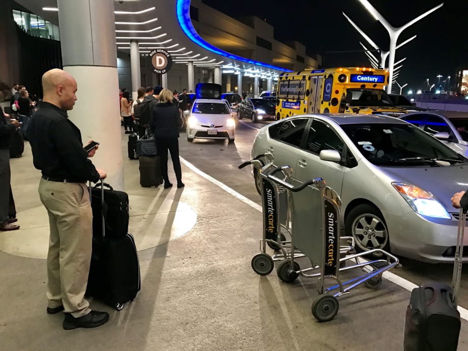
Curb data allows ride-hail drivers to easily identify regulated pick-up and drop-off spots.
Janna Starcic/METRO Magazine
7 min to read

In a world with scooters, bike-sharing, ride-hail, delivery services and, eventually, autonomous vehicles all changing the ways in which we navigate our roads, city planners and officials are quickly realizing the need to pay attention to one of the most important, yet vastly overlooked aspects of urban planning: the curb.
Whether you realize it or not, curbs and their regulations significantly impact citizens and businesses on a daily basis. For instance, curbs dictate where, when and for how long you can park, the dedicated use of a parking spot, such as loading, pick-up/drop-off or accessible parking, they type of vehicle a parking spot is reserved for (i.e. motorcyclists, taxis, trucks) — the list goes on. With so many varied curb uses dispersed across a city, in order to make the most effective decisions to maximize a streetscape, cities must have up-to-date information on curb assets that can then be incorporated into broader urban plans.
When city staffers, transportation planners, parking consultants, engineering firms and the multitude of others who work with curbs, have the right tools and information needed to understand the curb, city streets can reach their full potential. Meaning, more productive curbsides make cities more livable for residents.
Take, for example, the findings from the latest traffic index. The 2018 report showed that while traffic congestion rates were mostly on the rise in major cities, two U.S. cities: Salt Lake City and Portland, Oregon, saw a decrease in the time commuters spent in gridlock last year. To combat congestion and traffic frustrations in these major areas, both Salt Lake City and Portland used valuable curb data and evaluated community needs to make changes to bike infrastructure and parking areas that ultimately improved the livability and efficiency of these urban areas.
Nevada City, California just raised their ‘cute’ parking meter prices to help fund the threat of wildfires. They found that meter pricing was too low to even cover the salaries of the public works employees that maintained them. Getting a town to increase prices on meters is no easy feat, so the electorates attached a social cause to their mission, and ensured their community that the revenue would benefit them — by helping prevent wildfires from destroying their town. Of course not all residents were gung-ho to pay more for parking, but understanding the economics of their curbs was the first step town officials needed to take to ensure their town would still be standing in the future.

One of the companies working to create a better mobility experience is RoadBotics, a startup that uses AI and smartphones to track the deterioration of roads and curbs to help governments and engineering firms assess their road networks. The company just partnered with a sweeper company to collect pothole and pavement condition data during normal road sweeping operations in towns and cities across Florida. Omitting the need for tedious manual inspections, Roadbotics’ machine-vision system makes poor curb and pavement conditions more manageable, improving the mobility experience for locals and visitors.
Downtown Santa Monica is another place that is making major moves to incorporate the curb into its planning. The downtown area’s popularity paired with the increased usage of alternative mobility methods, like Bird’s scooters, Lyft’s rideshare and an abundance of food delivery options, make it ripe for a congestion nightmare.
Downtown Santa Monica Inc. is an innovative Business Improvement District, that is looking to increase foot traffic to their member businesses, but without a congestion or parking headache. They realized (like many other cities will also soon discover) if they want to continue supporting new modes of transport, while maintaining compliance and safety for the community, they would need to have a more robust understanding of curbside accessibility.
In order to approach the city and suggest appropriate changes to their district’s curbsides, they would need to know what every inch of their curb space currently looked like — from parking meters, loading zones, to curb cuts, ramps and more.
Having a detailed map of their curbsides, means they will be able to use a data-driven approach to help their case when approaching the city to make the necessary changes to improve parking, ride-hail and micro-mobility access for their community.
However, they wanted a better solution for collecting data compared to their previous methods of surveying wheels and paper curb data report. For this type of job, they’d want to create a digital record of their district’s curb that they can continue to iterate. And so they did.
Downtown Santa Monica Inc. worked with an augmented-reality app developed by Coord, called Surveyor, that easily and accurately captures curb data, using only an iPhone. With the ability to capture curb data an order of magnitude faster than traditional methods, Downtown Santa Monica Inc. collected and created a holistic view of the city’s curbs.
What was even better, is that a few members of the team captured the data themselves (not a hired engineering team) which gave them each a more granular understanding of how the district’s curbs were being used and allocated on a daily basis. This meant that not only did they create a clear digital map but they got deeper insights needed to approach the city with suggested mobility improvements that would support more residents and visitors being able to access the area and support the businesses that call Downtown Santa Monica their home.
“From deliveries to scooters, there is intense competition for curb space in Downtown Santa Monica. Having a complete picture of how, where and when our curbs are used helps us to adapt and designate the necessary space for our ever-changing environment while meeting the needs of our businesses and patrons.”
-Benjamin DeWitte, Research & Data Manager for Downtown Santa Monica
This new digital record of curb data offered new insights that not only changed urban planning for the bustling neighborhood of Downtown Santa Monica, but that can also be applied more broadly to any city:
Curb data can ease congestion: Areas like Downtown Santa Monica already battle parking wars from the mass of businesses dotted along the district. With curb data in their tool belt, city planners can not only allocate the right amount of parking spaces for cars, scooters and bicycles, but they can also create a dynamic curb that mirrors curbside supply and demand seen throughout the day to make transportation more accessible and efficient.

Curb data can improve traffic due to on-demand mobility options: With the rise in ride-hail services like Uber, Lyft and more, has come a dire need to better regulate dedicated pick-up and drop-off zones. Curb data allows ride-hail drivers to easily identify regulated pick-up and drop-off spots, cutting down on traffic blocks in the middle of city streets due to passenger loading as well as providing safe locations for passengers to enter and exit.
Curb data can facilitate on-time deliveries for businesses: In the age of quick delivery, it’s essential that there are proper loading and delivery zones for on-time deliveries. This also can be an advantage for small businesses to be able to differentiate based on better delivery schedules and help reduce crippling parking infractions.
Curb data can help cities prepare for the future: whether it is adjusting permit allocations, helping new mobility options enter, or even leveraging meter revenue for social causes or community improvements — cities can now take data driven approaches to ensuring their productivity is maximized so that as many people as possible are served by their curbsides.
Curb data helps inform constituents: by enabling clear communication across city agencies as well as to constituents such as businesses, residents and visitors — curb data can help garner support and assist in coordinating adoption of curbside changes. Everybody needs to be on the same page in order to coordinate most mobility and curbside changes that affect the community as a whole.
By utilizing innovative technology and working with new technology partners like Coord, cities can collect more accurate data and work with businesses, residents and visitors to improve efficiency and safety along the curb. With a digital baseline of city curbs, cities will be empowered to manage and adapt to the ever-changing nature of today’s mobility industry.
Stephen Smyth is the co-founder and CEO of Coord, Sidewalk Labs' integration platform for mobility providers, navigation tools, and urban infrastructure.
Subscribe to Our Newsletter
More Blog Posts
Velo-city Conference 2026: Latest Trends in Cycling as Part of Urban Mobility
The global cycling conference highlighted how cities are integrating bicycles into multimodal transportation networks, expanding cycle tourism and reshaping urban mobility.
Read More →
Kindness Isn’t Soft...It’s Strategic.
Mike Bismeyer — often known as “The Kindness Guy” — has spent more than 17 years in public transit and mobility, serving in industry leadership roles, speaking across North America, and advocating for stronger workplace cultures. But his message doesn’t come from theory. It comes from lived experience.
Read More →
Inside ITF 2026: Transport Reacts to A Challenging World
Transport leaders from around the world gathered in Leipzig, Germany, for the 2026 International Transport Forum to discuss resilience, climate impacts, supply chains and the future of sustainable mobility.
Read More →
Every Ride Tells a Story — But You’re Not Just Selling the Ride
You’re selling the moment, the meaning, and the emotion behind it.
Read More →
How Digital Signage is Reshaping the Traveler Experience at Transportation Hubs
What was once a landscape of static signs has evolved into a responsive, immersive environment powered by real-time visual communication.
Read More →
Latest Trends in Urban Mobility from Polis Conference 2025
Polis comprises cities and regions, as well as corporate partners, from across Europe, promoting the development and implementation of sustainable mobility. This year’s event had over a thousand attendees across various policy forums and an exhibition.
Read More →
Why Transit Leaders Require Better Tools for Operational Clarity In Today’s Tech-Fragmented Environment
Across North America and beyond, transit agency officials are contending with a perfect storm of operational headaches and strategic challenges that hamper daily service and long-term progress.
Read More →
The Powerless Brokers: Why California Can’t Build Transit
It is no secret that transit in the U.S. is slow and expensive to build.
Read More →
Why Transport Sustainability Should Focus on People Instead of Cars
Simply incentivizing electrification is not enough to make a meaningful impact; we must shift our focus toward prioritizing public transportation and infrastructure.
Read More →
Transit ROI & System Efficiencies Will Drive 'Big, Beautiful' Transit Funding
For many years, the narrative surrounding public transit improvements has been heavily weighted toward environmental gains and carbon reduction. While these are undeniably crucial long-term benefits, the immediate focus of this new funding environment is firmly on demonstrable system efficiencies and a clear return on investment.
Read More →